Dr.Teruo Higa’s
Living A Dream
- 2025
- Apr:#204 How EM Use Has Spread Throughout the Philippines
- Mar:#203 How to Use EM to Fundamentally Solve the Problem of Agricultural Residue Burning
- Feb:#202 The Spread of EM technology in Germany
- Jan:#201 The 2nd Ichiro Masaki Memorial Universal Village EM International Conference
- Jan:#200 Cleanup of the Ala Wai Canal in Hawaii, where social bonds are strengthened using EM
- 2024
- Nov:#199 EM trials in India with bananas, tomatoes, and pomegranates
- Oct:#198 The Steadily Evolving EM Nature Farming Method at the Blue Sky Palace - Part 8
- Sep:#197 The Steadily Evolving EM Nature Farming Method at the Blue Sky Palace - Part 7
- Aug:#196 The Steadily Evolving EM Nature Farming Method at the Blue Sky Palace - Part 6
- Jul:#195 The Steadily Evolving EM Nature Farming Method at the Blue Sky Palace - Part 5
- Jun:#194 Steadily Evolving EM Nature Farming Method at the Blue Sky Palace - Part 4
- May:#193 Steadily Evolving EM Nature Farming Method at the Blue Sky Palace - Part 3
- May:#192 Steadily Evolving EM Nature Farming Method at the Blue Sky Palace - Part 2
- Apr:#191 Steadily Evolving EM Nature Farming Method at the Blue Sky Palace
- Mar:#190 Quantum Mechanical Effects of EM Gravitron Charcoal
- Mar:#189 The barrier space in Okinawa (Ryukyu Islands) has risen to another dimension
- Jan:#188 Sixty Days after Typhoon No.6
- 2023
- Oct:#187 Supermassive Typhoon No.6 and Subsequent Typhoon No. 11
- Sep:#186 Massive Typhoon No.6 that swallowed the Ryukyu Islands Graviton barrier
- Sep:#185 August 8th is World “EM Mudball Day”
- Aug:#184 A disease-free life depends on the health of the intestinal microbiome.
- Jul:#183 Trial and Error at the Blue-Sky Palace, Part 3
- Jun:#182 Trial and Error at the Blue-Sky Palace, Part 2
- Apr:#181 Trial and Error at the Blue-Sky Palace
- Mar:#180 Ala Wai Canal Cleanup Project in Waikiki, Hawaii
- Feb:#179 High-Yield, High-Quality Rice Production Using EM
- Feb:#178 The Progress the "Soil Preparation Workshop" of the Oishi 3-chan Club (Part 2)
- Jan:#177 Organic Farming Instructional Manual Using EM
- 2022
- Nov:#176 The Typhoon Situation in Okinawa in 2022
- Sep:#175 Third-Party Verification of the Graviton barrier in Okinawa Part-2
- Sep:#174 Third-Party Verification of the Graviton barrier in Okinawa
- Aug:#173 Ecosystem Changes Observed in Okinawa in 2021 Part-5
- Jun:#172 Ecosystem Changes Observed in Okinawa in 2021 Part-4
- May:#171 Ecosystem Changes Observed in Okinawa in 2021 Part-3
- Apr:#170 Ecosystem Changes Observed in Okinawa in 2021 Part-2
- Mar:#169 Koizumi Farm in Kamakura Continues to Evolve
- Feb:#168 Ecosystem Changes Observed in Okinawa in 2021 Part-1
- 2021
- Dec:#167 Enjoying EM Technology While Enriching the Local Ecosystem
- Nov:#166 A Case Study of the Use of EM in a Next Generation Free School in Tune with the Cycles of Nature
- Oct:#165 Typhoon conditions and flowers in Okinawa from August to October
- Sep:#164 Re-learning the origins of river purification using EM Cleaning up the Dairyuji River in Senami (Murakami City, Niigata Prefecture)
- Aug:#163 Measures Against Natural Disasters and Re-learning the Starting Point of EM
- Jul:#162 Summary of FFC (Foods for Children) Okinawa Forum 2021
- Jun:#161 Restoring the Vigor of an Old Tree and Purifying the Environment with EM Technology That Even an Amateur Can Do
- May:#160 The Public is Beginning to Recognize the Use of EM Smokeless Carbonizers
- Apr:#159 EM Hado (EM Graviton) that exerts quantum superposition effect over time
- Mar:#158 Virus-free Okinawan Plants Through Use of an EM Graviton Barrier
- Jan:#157 Enjoyable Farming for Self-Sufficiency that Even Amateurs Can Do
- 2020
- Dec:#156 EM quantum energy effect occurring in Okinawa
- Nov:#155 Implementing EM graviton farming as a flood countermeasure for apple orchards
- Oct:#154 The Latest Book on the Practical Uses of EM "You Are the One Who Draws Out the Power of Microorganisms," by Chizuko Nomoto
- Sep:#153 Application of EM technology to long periods of rain, lack of sunshine, storms, heavy rains, etc.
- Aug:#152 EM application in Kitanakagusuku village plant waste recycling yard
- Jul:#151 Natural Disaster Countermeasures Using EM Technology: Part 2
- Jul:#150 Natural Disaster Countermeasures Using EM Technology
- May:#149 How to make your home and workplace an energy spot by living a complete EM lifestyle: creating the ultimate source of health and environmental purification
- Apr:#148 EM, Viruses and the Pandemic
- Apr:#147 New agriculture applying quantum mechanics Part 2
- Apr:#146 New agriculture applying quantum mechanics
- Apr:#145 Wonderful EM Miracle
- 2019
- Nov:#144 The movie “Revival II” and the reality of Fukushima
- Oct:#143 Boundary dome and foliar spraying of EM・X GOLD and EM 3
- Oct:#142 Kirakira (Sparkling) Summer Vegetable Festa in 2019
- Aug:#141 Excessive salt inevitably causes salt damage
- Jul:#140 Diverse applications of charcoal Part 3
- Jun:#139 Diverse applications of charcoal Part 2
- Jun:#138 Diverse applications of charcoal
- Jun:#137 Purification power of salt
- May:#136 The degree of soil contamination is a reflection of the microflora
- May:#135 Definitive use of EM barriers to deal with typhoons
- May:#134 Implementing authentic Nature Farming
- May:#133 How to enhance healthy Hado (wave energy) by EM
- May:#132 Eating Dirt (Soil)
- May:#131 Hado (Wave energy) involved in health
- May:#130 Reaffirming EM technology to realize the essence of agriculture
- May:#129 The 2nd EM Producer Networking Meeting
- Apr:#128 Understanding the application of seawater and salt in crop cultivation
- Apr:#127 Prevention of Disasters by EM Technology
- Mar:#126 Quantum overlay effective utilization of EM
- Jan:#125 EM Disaster Recovery Support Projects in 2017
- 2018
- 2017
- Aug:#121 Escape from conventional agricultural traps
- Jul:#120 Limitation and important caveats regarding utilization of salt
- Jun:#119 EM Technology to Break Through the Limits of Pesticide-Free Strawberries
- May:#118 Application of barriers using EM rectification force
- Apr:#117 The 1st EM Produce Growers' Networking Conference
- Mar:#116 Sumizo kun: The Ultimate Versatile Carbonization Equipment
- Feb:#115 How to make and use simple carbonized and rectified ash
- Jan:#114 Achievements of 2016
- 2016
- Dec:#113 Definitive Measures Against Typhoons
- Nov:#112 International Conference on Universal Village
- Oct:#111 90% of Your Body is Microbes
- Sep:#110 Disaster Countermeasures Using EM
- Aug:#109: Changes in the Natural Environment by EM Barrier Domes in Okinawa
- Jul:#108: Multi-purpose Utilization of Activated EM with Seawater and Salt
- Jun:#107: Marine Day, when EM Mudballs and Activated EM are Applied Throughout Japan
- May:#106: The Function of EM and Gravitational Waves–Part 3
- Apr:#105: The Function of EM and Gravitational Waves–Part 2
- Feb:#104: The Function of EM and Gravitational Waves
- Feb:#103: The Importance of Phototrophic Bacteria in EM
- 2015
- Dec:#102: Results of Environmental Forum "Utsukushima EM Paradise" 2015
- Nov:#101: Environmental Forum "Utsukushima EM Paradise" 2015
- Oct:#100: A New Phase of Limit Breakthrough Using EM
- Sep:#99: A New Phase of Limit Breakthrough through EM
- Aug:#98: The Tokyo Bay Area Began Creating a Truly Livable Hometown
- Jul:#97: Rectifying Effects of EM
- Jun:#96: Lake Suwa Sousei lecture
- May:#95: In Order to Further Ensure Limit Breakthrough
- Apr:#94: Theatrical Release of the Documentary Film SOSEI-Revival to Enlighten People on the New Possibilities of Microorganisms
- Mar:#93: What Underlies Limit Breakthrough (Part 2)
- Feb:#92: EM Functions to Break Through Limits
- Jan:#91: At the Start of 2015
- 2014
- Dec:#90: Looking Back at 2014
- Nov:#89: Shikoku EM FESTA 2014, Virtuous Circle Conference in Matsuyama, Ehime Prefecture
- Oct:#88: Using EM to Deal with Weather Disasters (Part 2)
- Sep:#87: Current Status of Radioactivity Measures Using EM in Fukushima
- Aug:#86: APNAN (Asia Pacific Natural Agriculture Network) 25th Anniversary Conference in 2014
- Jul:#85: Using EM to Deal with Weather Disasters
- Jun:#84: Substantial Improvement of Soil
- May:#83: The Energy Rectification Force of EM
- Apr:#82: The Annual 18th EM Technology Exchange Meeting and Tohoku Conference in Shichigahama
- Mar:#81: Salmon going upstream in Kitaura (Kasumigaura)
- Feb:#80: The Microbiome Again
- Jan:#79: Inauguration of the Federation of Diet Members Who Use and Apply Effective Microorganisms
- 2013
- Dec:#78: Receiving an Honorary Doctoral Degree from Rajamangala University of Technology in Thailand
- Nov:#77: The Use of EM in School Education in Bhutan
- Oct:#76: Well of Bonding
- Sep:#75: The Background to EM Not Being Employed by Public Institutions to Deal with Radiation
- Aug:#74: Dealing with Disaster: Using EM in Crisis Management
- Jul:#73: EM Events on Ocean Day
- Jun:#72: Using EM to Deal With Heat Stroke and Summer Heat Fatigue
- May:#71: An EM Model Town in Malaysia
- Apr:#70: Steps the Japanese Government is Taking to Deal with Radiation: Are They Really Safe?
- Mar:#69: EM Group Disaster Reconstruction Aid Project in Fukushima
- Feb:#68: EM and Microbiomes (Microbial Flora)
- Jan:#67: A Necessary Evil is Still Evil
- 2012
- Dec:#66: The 17th National EM Technology Exchange Conference / Hokkaido Conference in Sapporo
- Nov:#65: EM Forum 2012 in Okinawa and the Environmental Forum in Fukushima
- Oct:#64: 2012 EM Forum
- Sep:#63: A New Earth Saving Revolution
- Aug:#62: The Asahi Newspaper’s Misguided Reports About EM
- Jul:#61: Using EM in Radioactive Contamination Measures in Fukushima Prefecture
- Jun:#60: The Effects of Using EM to Inhibit the Absorption of Radioactivity as Confirmed in Fukushima
- May:#59: Recovery Support for the Great East Japan Earthquake
- Apr:#58: The Royal Kingdom of Thailand, in which EM Functions as a Set Government Policy
- Mar:#57: Report on the Measures Taken by Kingdom of Thailand Using EM to Deal with Polluted Water
- Feb:#56 EM™ as Part of National Policy in Thailand to Deal with Sanitation Issues Resulting from the Flood of 2011
- Jan:#55 The Law of Syntropy (Revitalization)
- 2011
- Dec:#54 EM Forum 2011
- Nov:#53 Shikoku EM Festa 2011- Zenjunkan no Wa (Virtuous Circle) Tokushima Conference in Naruto -
- Oct:#52 The Mystery of Interim Safety Values for Radioactive Material
- Sep:#51 Successful Radiation Countermeasures Using EM
- Aug:#50 Events on Sea Day in which EM Mud Balls are Thrown into the Water and Activated EM is Applied.
- May:#47 Dealing with the Damage Caused by the Eastern Japan Earthquake
- Apr:#46 Eastern Japan Earthquake
- Mar:#45 The 16th National EM Technology Hokuriku Conference in Fukui
- Feb:#44 More Thoughts on Avian Influenza and Foot-and-Mouth Disease
- Jan:#43 Happy New Year!
- 2010
- Dec:#42 Shikoku EM FESTA 2010・Zenjunkan no wa (Virtuous Circle) Fellowship Conference in Tobe, Ehime Prefecture
- Nov:#41 EM Forum 2010
- Oct:#40: My Thanks to the EM™ Volunteers Who Helped in the Fight Against Foot-and-Mouth Disease in Miyazaki Prefecture
- Sep:#39 International EM Mud Ball Day
- Jul:#37 Poland EM Forum 2010
- Jun:#36 EM Countermeasures Against Foot-and-Mouth Disease
- May:#35 Abnormal Weather
- Apr:#34 EM Activities in Thailand: Finding Solutions to the Challenges Facing the Nation
- Mar:#33 New Developments in the Evolution of EMTM in Thailand
- Feb:#32 Results Starting to Be Seen at the Mikasa Project
- Jan:#31 Towards an EM-Use Society
- 2009
- Dec:#30 EM Summit
- Nov:#29 The System in Penang State in Malaysia that Made the World EMTM Mudball Day a Success
- Oct:#28 The "World EM Mudball Day" in Malaysia
- Sep:#27 Validating EMTM Medicine: Case Study Reports from EM Users 2009. (Part 3)
- Sep:#26 Validating EMTM Medicine: Case Study Reports from EMTM Users 2009. (Part 2)
- Jul:#25 Validating EMTM Medicine: Case Study Reports from EMTM Users 2009. (Part 1)
- Jun:#24 Activities to Disseminate EM-Focused Nature Farming in China
- May:#23 Use of EMTM in Response to Swine Flu
- Apr:#22 Using EM to Solve Public Administrative Costs
- Mar:#21 Reaffirming the Versatility of EM
- Jan:#20 The Beginning of a New Era
- 2008
#187 Supermassive Typhoon No.6 and Subsequent Typhoon No. 11

In the previous issues, I explained the situation of supermassive Typhoon No. 6, which engulfed the 700 km long EM Graviton Barrier in the Ryukyu Islands. Conventional wisdom would dictate that it would take several years or more to recover from the damage, but as I noted at the end of the previous issue, the effects of the EM Graviton Barrier are clearly evident. Figure 1 below shows the status of shipments of “the earliest green-cut Unshu mandarin oranges in Japan,” which began under my supervision. I am quite relieved to see that all, impossible in my previous experience, would be a reality. Now, more than thirty days after the typhoon passed, nature has recovered so fully that it makes us wonder if the typhoon was merely a dream. In the past, all of this would have been unimaginable.
Earliest Shipment of Unshu Mandarin Oranges in Japan
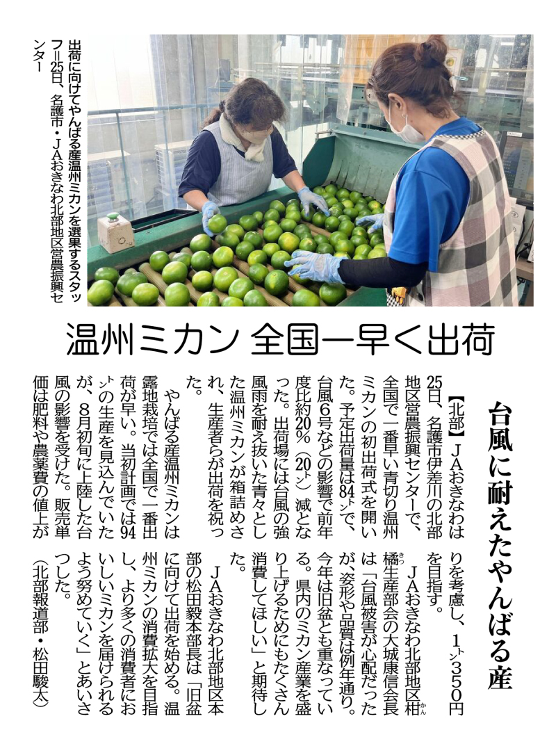
On August 25th, JA Okinawa held a ceremony marking the first shipment of green-cut Unshu mandarin oranges, the earliest in Japan, at the Northern Region Agricultural Promotion Center in Isagawa, Nago City, Okinawa Prefecture. The amount planned to be shipped came to 84 tons, a decrease of about 20% (20 tons) from the previous year due to the effects of Typhoon No. 6 and other factors. At the shipping site, boxes of lush green Unshu mandarin oranges that had survived the typhoon’s strong winds and rain were packed, and the growers celebrated the shipment.
Yanbaru-grown Unshu mandarine oranges are the earliest open-air cultivated ones to be shipped in Japan. The original production plan was for 94 tons, but the crop was negatively impacted by the typhoon that made landfall in early August. The unit sales price is targeted at 350 yen per kilogram, taking into account the increased cost of fertilizers and pesticides.
Yasunobu Oshiro, chairman of the JA Okinawa Northern District Citrus Production Committee, said, “We were worried about typhoon damage, but the shape and quality are the same as usual. This year’s harvest also coincides with the lunar calendar-based Obon festival. I hope that people will consume a lot of them to boost the prefecture’s Unshu mandarin orange industry.”
Tsuyoshi Matsuda, general manager of the JA Okinawa Northern Regional Headquarters, said, “We will start shipping for the Obon festival holiday. We will do our best to expand the consumption of Unshu mandarin oranges and deliver delicious mandarins to as many consumers as possible.”
(Shunta Matsuda, Northern News Department)
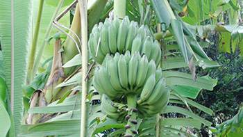
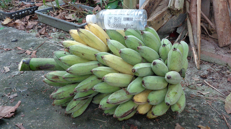
In the last issue, I discussed the typhoon damage to my private garden, the Blue Sky Palace, and stated that it would take until December to restore it, but here is the present condition as of thirty days after the typhoon passed (same location as Photo 1 in the previous issue). If things continue in this way, I believe that by the end of September to mid-October, the results will be better than the areas we upgraded after right after the typhoon).
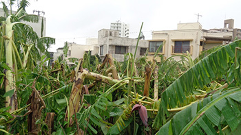
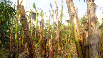
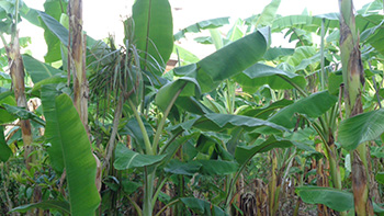
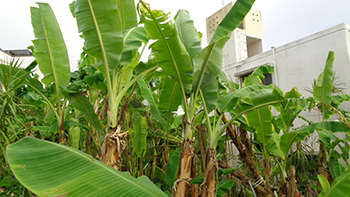
The key to recovery was the application of 50 kg of salt and 200 liters of activated EM per 10 acres immediately after the typhoon while the soil was sufficiently moist, and spraying EM・X GOLD daily in one spot to strengthen the EM graviton barrier and the Hado waves of the drip. Two weeks later, I applied a mixture of half EM Gravitron charcoal and half salt, using 15 kg per 10 acres. Fertilizing in this way produced remarkable effects, and the new leaves that have regenerated from the broken trunks have been thick and dwarfed. This result may lead to banana dwarfism (plants becoming shorter and smaller in size), which was previously thought to be impossible.
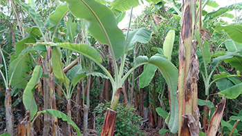
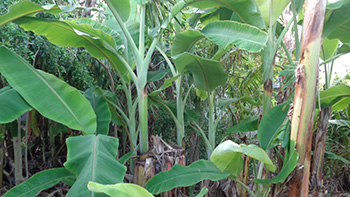
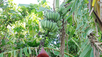
The banana plants in the less damaged areas showed unexpected growth and yielded some of the most magnificent fruits I have ever seen. The remaining fruits and flowers mentioned in the previous issue are steadily growing and will soon yield a good harvest.
Verifying the effectiveness of the EM graviton barrier in the Ryukyu Islands against Typhoon No.11
Typhoon No. 11 hit Taiwan on September 3rd, and then reached mainland China, causing various damage. According to the forecast before August 30th, it would hit the main island of Okinawa directly, but as with previous typhoons, it began to shift significantly to the south and was pushed south of Ishigaki Island, that is, outside the EM Graviton barrier, on August 1st. (See the weather maps in Figures 2 and 3.) My hope is that we will continue to verify the data and utilize it in our efforts to counteract climate change.
Typhoon No. 11 hit Taiwan on September 3rd, and then reached mainland China, causing various damage. According to the forecast before August 30th, it would hit the main island of Okinawa directly, but as with previous typhoons, it began to shift significantly to the south and was pushed south of Ishigaki Island, that is, outside the EM Graviton barrier, on August 1st. (See the weather maps in Figures 2 and 3.) My hope is that we will continue to verify the data and utilize it in our efforts to counteract climate change.
Typhoon No. 11 approaches Okinawa region
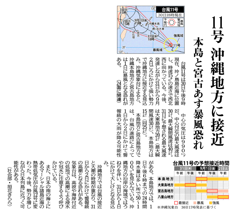
Threat of stormy winds on the main island and Miyako tomorrow
As of 9 p.m. on September 30th Typhoon No. 11 is located near Okinotori Island, heading west-northwest at a speed of 15 km/h. It is expected to continue to develop and approach the Okinawa region with strong force from the 31st to around September 2nd. According to the Okinawa Meteorological Observatory, the Okinawa main island and Miyako Island area are at risk of becoming stormy on the 1st.
The central pressure of the typhoon is 990 hectopascals, the maximum wind speed near the center is 30 meters, and the maximum instantaneous wind speed is 40 meters. The predicted maximum instantaneous wind speed on the 31st is 20 meters (with a maximum instantaneous wind speed of 30 meters) in the Daito Islands area, 15 meters in the Okinawa Main Island (with a maximum instantaneous wind speed of 25 meters).
Depending on the path the typhoon follows, warning-level heavy rainfall is possible in the main island and the Miyako Island region. In the main island region, 24-hour precipitation amounts of 50 to 100 millimeters are expected by 6 p.m. on September 1st. It is expected to cause heavy swells in the coastal waters of the Okinawa region and heavy seas are expected from the 31st to September 1st.
In the Okinawa region, the approach of a typhoon coincides with the period of high tides, and there is a risk of warning-level storm surges from the 31st to September 2nd. The meteorological observatory is advising people to be careful of flooding caused by high waves and high tides in low-lying areas near the coast. In addition, a tropical cyclone near the Marshall Islands, located off the southern coast of Japan, has turned into Typhoon No. 12. There is a possibility that it will approach the Japanese archipelago as it gains strength.
(Kirara Kakihana, Social Affairs Department)
Risk of Strong Winds Hitting the Sakishima Islands Today
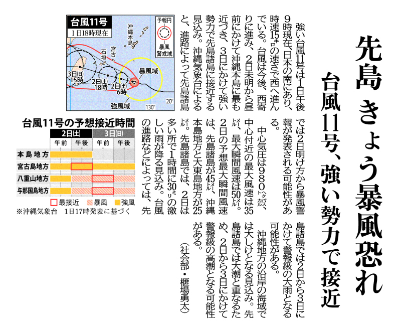
Typhoon No. 11, Approaching Japan with Strong Force
Strong typhoon No. 11, south of Japan as of 9 p.m. on September 1st, is moving westward at a speed of 15 km/h. The typhoon is expected to continue moving westward, coming closest to the main island of Okinawa from early morning to noon on the 2nd, and approaching the Sakishima Islands with strong force by the 3rd. The Okinawa Meteorological Observatory reports that a storm warning may be issued for the Sakishima Islands from dawn on the 2nd, depending on the path the storm takes.
The central pressure of the typhoon is 980 hectopascals, the maximum wind speed near the center is 35 meters, and the maximum instantaneous wind speed is 50 meters. The predicted maximum instantaneous wind speed on the 2nd is 45 meters in the Sakishima Islands and 25 meters in the Okinawa main island and the Daito Island regions.
In the Sakishima Islands, heavy rainfall of up to 30 millimeters per hour is expected on the 2nd. Depending on the typhoon’s path, there is possibility of such heavy rain in the Sakishima Islands from the 2nd and the 3rd that a warning may be issued. Heavy seas are expected off the Okinawan coast. The Sakishima Islands may experience a warning-level storm surge on the 2nd and 3rd to coinciding with high tides.
(Yuta Hiba, Social Affairs Department)
Editor’s Picks
-

#196 The Steadily Evolving EM Nature Farming Method at the Blue Sky Palace - Part 6 -

#195 The Steadily Evolving EM Nature Farming Method at the Blue Sky Palace - Part 5 -

#191 Steadily Evolving EM Nature Farming Method at the Blue Sky Palace -

#190 Quantum Mechanical Effects of EM Gravitron Charcoal
- 2025
- Apr:#204 How EM Use Has Spread Throughout the Philippines
- Mar:#203 How to Use EM to Fundamentally Solve the Problem of Agricultural Residue Burning
- Feb:#202 The Spread of EM technology in Germany
- Jan:#201 The 2nd Ichiro Masaki Memorial Universal Village EM International Conference
- Jan:#200 Cleanup of the Ala Wai Canal in Hawaii, where social bonds are strengthened using EM
- 2024
- Nov:#199 EM trials in India with bananas, tomatoes, and pomegranates
- Oct:#198 The Steadily Evolving EM Nature Farming Method at the Blue Sky Palace - Part 8
- Sep:#197 The Steadily Evolving EM Nature Farming Method at the Blue Sky Palace - Part 7
- Aug:#196 The Steadily Evolving EM Nature Farming Method at the Blue Sky Palace - Part 6
- Jul:#195 The Steadily Evolving EM Nature Farming Method at the Blue Sky Palace - Part 5
- Jun:#194 Steadily Evolving EM Nature Farming Method at the Blue Sky Palace - Part 4
- May:#193 Steadily Evolving EM Nature Farming Method at the Blue Sky Palace - Part 3
- May:#192 Steadily Evolving EM Nature Farming Method at the Blue Sky Palace - Part 2
- Apr:#191 Steadily Evolving EM Nature Farming Method at the Blue Sky Palace
- Mar:#190 Quantum Mechanical Effects of EM Gravitron Charcoal
- Mar:#189 The barrier space in Okinawa (Ryukyu Islands) has risen to another dimension
- Jan:#188 Sixty Days after Typhoon No.6
- 2023
- Oct:#187 Supermassive Typhoon No.6 and Subsequent Typhoon No. 11
- Sep:#186 Massive Typhoon No.6 that swallowed the Ryukyu Islands Graviton barrier
- Sep:#185 August 8th is World “EM Mudball Day”
- Aug:#184 A disease-free life depends on the health of the intestinal microbiome.
- Jul:#183 Trial and Error at the Blue-Sky Palace, Part 3
- Jun:#182 Trial and Error at the Blue-Sky Palace, Part 2
- Apr:#181 Trial and Error at the Blue-Sky Palace
- Mar:#180 Ala Wai Canal Cleanup Project in Waikiki, Hawaii
- Feb:#179 High-Yield, High-Quality Rice Production Using EM
- Feb:#178 The Progress the "Soil Preparation Workshop" of the Oishi 3-chan Club (Part 2)
- Jan:#177 Organic Farming Instructional Manual Using EM
- 2022
- Nov:#176 The Typhoon Situation in Okinawa in 2022
- Sep:#175 Third-Party Verification of the Graviton barrier in Okinawa Part-2
- Sep:#174 Third-Party Verification of the Graviton barrier in Okinawa
- Aug:#173 Ecosystem Changes Observed in Okinawa in 2021 Part-5
- Jun:#172 Ecosystem Changes Observed in Okinawa in 2021 Part-4
- May:#171 Ecosystem Changes Observed in Okinawa in 2021 Part-3
- Apr:#170 Ecosystem Changes Observed in Okinawa in 2021 Part-2
- Mar:#169 Koizumi Farm in Kamakura Continues to Evolve
- Feb:#168 Ecosystem Changes Observed in Okinawa in 2021 Part-1
- 2021
- Dec:#167 Enjoying EM Technology While Enriching the Local Ecosystem
- Nov:#166 A Case Study of the Use of EM in a Next Generation Free School in Tune with the Cycles of Nature
- Oct:#165 Typhoon conditions and flowers in Okinawa from August to October
- Sep:#164 Re-learning the origins of river purification using EM Cleaning up the Dairyuji River in Senami (Murakami City, Niigata Prefecture)
- Aug:#163 Measures Against Natural Disasters and Re-learning the Starting Point of EM
- Jul:#162 Summary of FFC (Foods for Children) Okinawa Forum 2021
- Jun:#161 Restoring the Vigor of an Old Tree and Purifying the Environment with EM Technology That Even an Amateur Can Do
- May:#160 The Public is Beginning to Recognize the Use of EM Smokeless Carbonizers
- Apr:#159 EM Hado (EM Graviton) that exerts quantum superposition effect over time
- Mar:#158 Virus-free Okinawan Plants Through Use of an EM Graviton Barrier
- Jan:#157 Enjoyable Farming for Self-Sufficiency that Even Amateurs Can Do
- 2020
- Dec:#156 EM quantum energy effect occurring in Okinawa
- Nov:#155 Implementing EM graviton farming as a flood countermeasure for apple orchards
- Oct:#154 The Latest Book on the Practical Uses of EM "You Are the One Who Draws Out the Power of Microorganisms," by Chizuko Nomoto
- Sep:#153 Application of EM technology to long periods of rain, lack of sunshine, storms, heavy rains, etc.
- Aug:#152 EM application in Kitanakagusuku village plant waste recycling yard
- Jul:#151 Natural Disaster Countermeasures Using EM Technology: Part 2
- Jul:#150 Natural Disaster Countermeasures Using EM Technology
- May:#149 How to make your home and workplace an energy spot by living a complete EM lifestyle: creating the ultimate source of health and environmental purification
- Apr:#148 EM, Viruses and the Pandemic
- Apr:#147 New agriculture applying quantum mechanics Part 2
- Apr:#146 New agriculture applying quantum mechanics
- Apr:#145 Wonderful EM Miracle
- 2019
- Nov:#144 The movie “Revival II” and the reality of Fukushima
- Oct:#143 Boundary dome and foliar spraying of EM・X GOLD and EM 3
- Oct:#142 Kirakira (Sparkling) Summer Vegetable Festa in 2019
- Aug:#141 Excessive salt inevitably causes salt damage
- Jul:#140 Diverse applications of charcoal Part 3
- Jun:#139 Diverse applications of charcoal Part 2
- Jun:#138 Diverse applications of charcoal
- Jun:#137 Purification power of salt
- May:#136 The degree of soil contamination is a reflection of the microflora
- May:#135 Definitive use of EM barriers to deal with typhoons
- May:#134 Implementing authentic Nature Farming
- May:#133 How to enhance healthy Hado (wave energy) by EM
- May:#132 Eating Dirt (Soil)
- May:#131 Hado (Wave energy) involved in health
- May:#130 Reaffirming EM technology to realize the essence of agriculture
- May:#129 The 2nd EM Producer Networking Meeting
- Apr:#128 Understanding the application of seawater and salt in crop cultivation
- Apr:#127 Prevention of Disasters by EM Technology
- Mar:#126 Quantum overlay effective utilization of EM
- Jan:#125 EM Disaster Recovery Support Projects in 2017
- 2018
- 2017
- Aug:#121 Escape from conventional agricultural traps
- Jul:#120 Limitation and important caveats regarding utilization of salt
- Jun:#119 EM Technology to Break Through the Limits of Pesticide-Free Strawberries
- May:#118 Application of barriers using EM rectification force
- Apr:#117 The 1st EM Produce Growers' Networking Conference
- Mar:#116 Sumizo kun: The Ultimate Versatile Carbonization Equipment
- Feb:#115 How to make and use simple carbonized and rectified ash
- Jan:#114 Achievements of 2016
- 2016
- Dec:#113 Definitive Measures Against Typhoons
- Nov:#112 International Conference on Universal Village
- Oct:#111 90% of Your Body is Microbes
- Sep:#110 Disaster Countermeasures Using EM
- Aug:#109: Changes in the Natural Environment by EM Barrier Domes in Okinawa
- Jul:#108: Multi-purpose Utilization of Activated EM with Seawater and Salt
- Jun:#107: Marine Day, when EM Mudballs and Activated EM are Applied Throughout Japan
- May:#106: The Function of EM and Gravitational Waves–Part 3
- Apr:#105: The Function of EM and Gravitational Waves–Part 2
- Feb:#104: The Function of EM and Gravitational Waves
- Feb:#103: The Importance of Phototrophic Bacteria in EM
- 2015
- Dec:#102: Results of Environmental Forum "Utsukushima EM Paradise" 2015
- Nov:#101: Environmental Forum "Utsukushima EM Paradise" 2015
- Oct:#100: A New Phase of Limit Breakthrough Using EM
- Sep:#99: A New Phase of Limit Breakthrough through EM
- Aug:#98: The Tokyo Bay Area Began Creating a Truly Livable Hometown
- Jul:#97: Rectifying Effects of EM
- Jun:#96: Lake Suwa Sousei lecture
- May:#95: In Order to Further Ensure Limit Breakthrough
- Apr:#94: Theatrical Release of the Documentary Film SOSEI-Revival to Enlighten People on the New Possibilities of Microorganisms
- Mar:#93: What Underlies Limit Breakthrough (Part 2)
- Feb:#92: EM Functions to Break Through Limits
- Jan:#91: At the Start of 2015
- 2014
- Dec:#90: Looking Back at 2014
- Nov:#89: Shikoku EM FESTA 2014, Virtuous Circle Conference in Matsuyama, Ehime Prefecture
- Oct:#88: Using EM to Deal with Weather Disasters (Part 2)
- Sep:#87: Current Status of Radioactivity Measures Using EM in Fukushima
- Aug:#86: APNAN (Asia Pacific Natural Agriculture Network) 25th Anniversary Conference in 2014
- Jul:#85: Using EM to Deal with Weather Disasters
- Jun:#84: Substantial Improvement of Soil
- May:#83: The Energy Rectification Force of EM
- Apr:#82: The Annual 18th EM Technology Exchange Meeting and Tohoku Conference in Shichigahama
- Mar:#81: Salmon going upstream in Kitaura (Kasumigaura)
- Feb:#80: The Microbiome Again
- Jan:#79: Inauguration of the Federation of Diet Members Who Use and Apply Effective Microorganisms
- 2013
- Dec:#78: Receiving an Honorary Doctoral Degree from Rajamangala University of Technology in Thailand
- Nov:#77: The Use of EM in School Education in Bhutan
- Oct:#76: Well of Bonding
- Sep:#75: The Background to EM Not Being Employed by Public Institutions to Deal with Radiation
- Aug:#74: Dealing with Disaster: Using EM in Crisis Management
- Jul:#73: EM Events on Ocean Day
- Jun:#72: Using EM to Deal With Heat Stroke and Summer Heat Fatigue
- May:#71: An EM Model Town in Malaysia
- Apr:#70: Steps the Japanese Government is Taking to Deal with Radiation: Are They Really Safe?
- Mar:#69: EM Group Disaster Reconstruction Aid Project in Fukushima
- Feb:#68: EM and Microbiomes (Microbial Flora)
- Jan:#67: A Necessary Evil is Still Evil
- 2012
- Dec:#66: The 17th National EM Technology Exchange Conference / Hokkaido Conference in Sapporo
- Nov:#65: EM Forum 2012 in Okinawa and the Environmental Forum in Fukushima
- Oct:#64: 2012 EM Forum
- Sep:#63: A New Earth Saving Revolution
- Aug:#62: The Asahi Newspaper’s Misguided Reports About EM
- Jul:#61: Using EM in Radioactive Contamination Measures in Fukushima Prefecture
- Jun:#60: The Effects of Using EM to Inhibit the Absorption of Radioactivity as Confirmed in Fukushima
- May:#59: Recovery Support for the Great East Japan Earthquake
- Apr:#58: The Royal Kingdom of Thailand, in which EM Functions as a Set Government Policy
- Mar:#57: Report on the Measures Taken by Kingdom of Thailand Using EM to Deal with Polluted Water
- Feb:#56 EM™ as Part of National Policy in Thailand to Deal with Sanitation Issues Resulting from the Flood of 2011
- Jan:#55 The Law of Syntropy (Revitalization)
- 2011
- Dec:#54 EM Forum 2011
- Nov:#53 Shikoku EM Festa 2011- Zenjunkan no Wa (Virtuous Circle) Tokushima Conference in Naruto -
- Oct:#52 The Mystery of Interim Safety Values for Radioactive Material
- Sep:#51 Successful Radiation Countermeasures Using EM
- Aug:#50 Events on Sea Day in which EM Mud Balls are Thrown into the Water and Activated EM is Applied.
- May:#47 Dealing with the Damage Caused by the Eastern Japan Earthquake
- Apr:#46 Eastern Japan Earthquake
- Mar:#45 The 16th National EM Technology Hokuriku Conference in Fukui
- Feb:#44 More Thoughts on Avian Influenza and Foot-and-Mouth Disease
- Jan:#43 Happy New Year!
- 2010
- Dec:#42 Shikoku EM FESTA 2010・Zenjunkan no wa (Virtuous Circle) Fellowship Conference in Tobe, Ehime Prefecture
- Nov:#41 EM Forum 2010
- Oct:#40: My Thanks to the EM™ Volunteers Who Helped in the Fight Against Foot-and-Mouth Disease in Miyazaki Prefecture
- Sep:#39 International EM Mud Ball Day
- Jul:#37 Poland EM Forum 2010
- Jun:#36 EM Countermeasures Against Foot-and-Mouth Disease
- May:#35 Abnormal Weather
- Apr:#34 EM Activities in Thailand: Finding Solutions to the Challenges Facing the Nation
- Mar:#33 New Developments in the Evolution of EMTM in Thailand
- Feb:#32 Results Starting to Be Seen at the Mikasa Project
- Jan:#31 Towards an EM-Use Society
- 2009
- Dec:#30 EM Summit
- Nov:#29 The System in Penang State in Malaysia that Made the World EMTM Mudball Day a Success
- Oct:#28 The "World EM Mudball Day" in Malaysia
- Sep:#27 Validating EMTM Medicine: Case Study Reports from EM Users 2009. (Part 3)
- Sep:#26 Validating EMTM Medicine: Case Study Reports from EMTM Users 2009. (Part 2)
- Jul:#25 Validating EMTM Medicine: Case Study Reports from EMTM Users 2009. (Part 1)
- Jun:#24 Activities to Disseminate EM-Focused Nature Farming in China
- May:#23 Use of EMTM in Response to Swine Flu
- Apr:#22 Using EM to Solve Public Administrative Costs
- Mar:#21 Reaffirming the Versatility of EM
- Jan:#20 The Beginning of a New Era
- 2008
